Spatial analytics -course introduces you to different analysis approaches and methods of spatio-statistical analysis, geostatistics, map algebra and geovisual analysis. After the course, you can identify appropriate analysis approaches for different geospatial tasks, and describe data needs and suitable methods for the given analysis process. You can discuss the strengths and limitations of the methods. The course has been developed at the Department of Built Environment, Aalto University, Finland, and the materials are openly available for anyone interested.
Learning objectives#
After completing this course, you should:
understand the typical data analysis workflow
understand the basics of geostatistics and the associated terminology and mathematical principles
understand the basic principles of map overlay and map algebra
understand the principles of graph theory and network analysis
understand the basic principles of spatio-temporal multivariate analysis
be able to apply the previous concepts to different geographical problems using Python programming language
Prerequirements#
Before taking this course, it is required to know the basics of Python programming as well as GIS. If you are new to Python, or would like to refresh your Python skills, we recommend to start with an online and open access course called Geo-Python which is available at geo-python.github.io. If you need to refresh your Python GIS skills, we recommend starting with a course Automating GIS-processes available at autogis.github.io. Both of these courses include tutorials, videos and exercises.
Help improving the materials
This is version 3.
The course was given for the very first time in its current form in 2021, meaning that the content of the course is likely to change and
improve after each time the course is given (all versions will be available). By being a fully open
educational resource, you can also help making the course better.
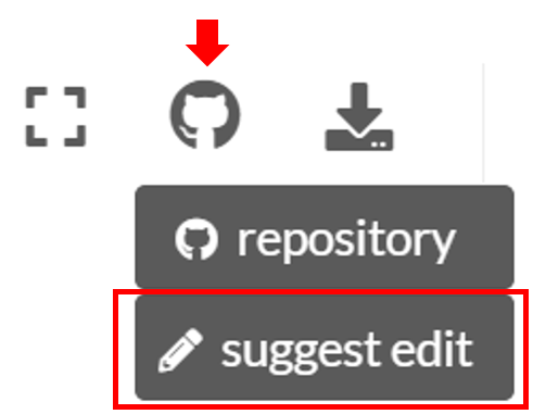
If you find any errors, typos, or other problems, please help, by suggesting an edit in GitHub. You can do this easily by clicking
suggest edit under the GitHub icon located at
the top-right on each page:
If you have good ideas about what should be taught, i.e. what methods, interesting datasets or literature should be introduced during the course, you can suggest and bring your ideas forward by raising an issue in GitHub.
Credits
This course was originally developed by Prof. Kirsi Virrantaus at Aalto University, who has very much inspired how it is taught in its current form. Also Marko Kallio, Jaakko Madetoja and Salla Multimäki have contributed to the materials and exercises. Here, the materials are somewhat updated, restructured and aligned to work with Python spatial data science ecosystem, and the online learning ecosystem used in the course.
Course format#
The majority of this course will be spent in front of a computer writing code with the Python language. The course consists of lectures, tutorials and weekly exercises. The exercises will focus on applying the introduced methods to given geographical problems.
Most exercises in this course involve real world examples and data. For each exercise, you may be asked to submit the Python codes you have written, output figures and answers to related questions. You are encouraged to discuss and work together with other students while working on the weekly exercises.
Aalto University students
The Spatial Analytics -course is part of the
Master’s Programme of Geoinformatics at Aalto University
under the course code GIS-E1060.
Interactive contents
Each tutorial in this course can be turned into an interactive programming session in the browser. You can find buttons for activating the python environment using Binder at the top of each programming lesson. Students at Finnish higher education institutions are encouraged to use the CSC notebooks environment.
Program#
The course includes two lectures per week and is held at the Aalto University starting on Tuesday in the second teaching period. Topics per Lesson are listed below. Please note that this web page is updated each week before the given lesson:
Lesson |
Themes |
|---|---|
1 |
|
2 |
|
3 |
|
4 |
|
5 |
|
6 |
|
7 |
|
8 |
|
9 |
|
10 |
|
Contents#
Course information
Week 1
Week 4